


Perihal Surveyor
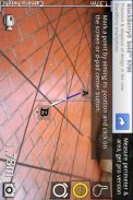
With Surveyor, you can measure distances by placing markers on a virtual ground that is overlaid on the camera image.
Surveyor locks the virtual ground to the real world so no matter which direction you turn to, the markers will always stay where it is originally placed.
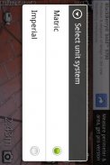
Distances between each markers are calculated and displayed on the screen in the unit system you specified. With the pro version you can place more than 2 markers and even get the area of the space surrounded by the markers.
</div> <div jsname="WJz9Hc" style="display:none">Dengan Juruukur, anda boleh mengukur jarak dengan meletakkan petanda di atas tanah maya yang dilapisi pada imej kamera.
Juruukur mengunci tanah maya kepada dunia sebenar jadi tidak kira arah mana anda menghidupkan, petanda akan sentiasa kekal di mana ia asalnya diletakkan.
Jarak antara setiap penanda dikira dan dipaparkan pada skrin dalam sistem unit yang anda tetapkan. Dengan versi pro, anda boleh meletakkan lebih daripada 2 penanda dan juga mendapatkan kawasan ruang yang dikelilingi oleh petanda.</div> <div class="show-more-end">
Surveyor - Versi 2.5.2
(14-02-2013)Surveyor - Maklumat APK
Versi APK: 2.5.2Pakej: com.miian.android.surveyorAplikasi dalam kategori sama
Anda juga mungkin suka...


